By Randy Renier I. Espinoza


What does Nueva Ecija have to offer besides rice paddies? Many years ago, the default answer is Pantabangan Dam, which is but a man-made structure carved out of a natural terrain. In recent years, the Taong Putik Festival in Aliaga has caught the fancy of novelty-seeking tourists, and a few falls have been eyed as potential tourist attractions. Are these enough to put the province on the tourism map? No.
But then there's Minalungao National Park.
I read a little about Minalungao many years ago, mentioned as a tourist destination in a textbook or perhaps an information leaflet, but I did not endeavor to learn more about it. Truth is, there was very little written about it. It was often overlooked as a provincial tourist attraction, even among Novo Ecijanos themselves. It has always been overshadowed by the overrated Pantabangan Dam, which has frequently been promoted as the province’s major place of interest. Even the Wikipedia article on General Tinio (the municipality that has jurisdiction over the national park) doesn’t contain a photo of Minalungao, and a Facebook page dedicated to the park only has 3,227 likes (as of this posting).

I rediscovered Minalungao National Park when I learned
last year that some relatives had visited the site. This was a place I knew of
but knew little about. I didn’t even have a mental image of what it was like,
so I did some research. And when I saw photos on
the Web, I became interested and decided I, being a Novo Ecijano, had to see
the site as soon as possible. And I did on March 2.
Minalungao National Park
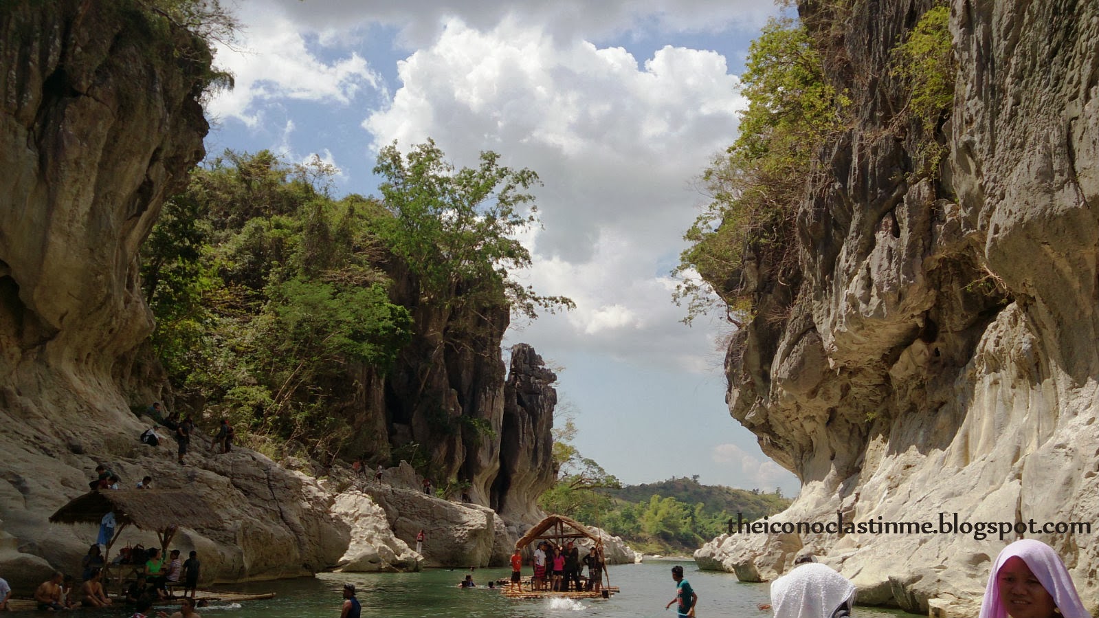
Established in 1967 by virtue of Republic Act No. 5100, the park is “a protected area of the Philippines located in the municipality of General Tinio, Nueva Ecija in Central Luzon. The park covers an area of 2,018 hectares centered along the scenic Penaranda River bordered on both sides by up to 16-meter high limestone walls in the foothills of the Sierra Madre mountain range.” (Wikipedia) The statute mentions that the park is “situated in the municipalities of Gapan and General Tinio,” but the portion of the park that is of focal interest for tourists is under the jurisdiction of the municipality of General Tinio. The tourist hub of this protected area, governed by the Department of Environment and Natural Resources, is situated in Sitio Minalungao, Papaya, old name of General Tinio.

The travel offers tourists panoramic views of rice fields, gently rolling slopes and sometimes craggy terrain of the countryside. The route ends at the welcome marker, bearing the name of the park, erected on a mound. From the marker, a further drive or short walk downhill will lead tourists to the foot of the slope, a junction, a sort of open dirt “lobby” or “reception area” where some vehicles can park, tourists can ask for information and hire local residents as guides. On weekends, youngsters and teenagers do guiding chores to earn some bucks. There is no fixed rates for guides, but a reasonable rate is 100 Php to 150 Php per guide. It is customary that two guides accompany a group of vacationers. They stay with the group in activities that required their knowhow, such as trekking, spelunking, uphill climbing, rafting, and cliff diving.

The "junction" adjoins a small bridge, crudely made of steel, that can only carry pedestrian traffic. Facing the “catch basin” portion of the river, where some cottages made up of bamboo and nipa line its banks, one can see parts of the ravine, the central spot of the protected site, to the right, and the meandering portion of the river to the left. From the junction, one can take the bridge, where the trek along the cliff starts, or descend toward the flat bank of the “catch basin,” where the cottages are located.
‘Catch Basin’
Activities start here. Along its banks are cottages where tourists can eat, rest, hang out, and even cook food. Rental rates for the cottages depend on the season, the cottage owner, one’s bargaining skills, and perhaps the number of occupants. During off-peak seasons, prices may start at 200 to 250 for a cottage unit. During peak seasons, usually summer and Holy Week, prices may rise to 500 per unit. A higher rate (800 on average) applies for floating cottages, which can navigate the main river and anchor at certain spots.
One can swim on the edges of the river, but may need to refrain from wandering towards the inner waters, as it gets deeper towards the center. Locals are quick to remind tourists that the deep part of the basin is infamous for pulling those who drift towards it and that it has taken many lives. Children can build sand castles on the banks. Others can roam around and go towards the shallow part of the river where it starts to meander downstream. They can wade across the mildly gushing waters over stones and pebbles towards the other side of the river, where there are other cottages.


The Ravine and the River
What I call the “ravine” is the valley formed by the flow of the Penaranda River. The calm waters of the narrow river straddle two towering limestone cliffs. The water in this area of the river, fed by headwaters coming from the Sierra Madre, is green and pristine and the unique rock formations at the bottom part of the karst cliffs appear whitewashed or like asbestos in color when struck by noontime sunlight. This ravine-river system is the centerpiece of the entire Minalungao experience. It constitutes the allure and grandeur of the national park.

The Trek
The other activity besides swimming that is a must-do for tourists, especially to the adventure seekers, is trekking. The entire trek is actually short but can be difficult as most of it entails some climbing and holding onto rocks and boulders. Think of rock climbing, but without the pegs and a rope to support you and minus the vertical, mostly 90-degree, climbs. The trail begins at the bridge, leading towards some boulders and a sort of “viewing deck,” which is just a cemented square pad where one can have a vantage point of the catch basin and the downstream river, the hill that bears the cross and the “grotto” and where a resort/hotel is being constructed, and major portions of the ravine and the green waters. Elderly people, young children, and those who don’t have enough stamina are encouraged not to go beyond this point.


What
follows is an undulating trail along the foot and lower part of the cliff wall
that goes up and goes down at various points and at varying degrees of slope.
Along the trek, one can have a more proximate perspective of the main river,
the cliff and the rock formations. If one wants to see the beauty of the karst
landform and the river at its best, trekking is the best way to do it.
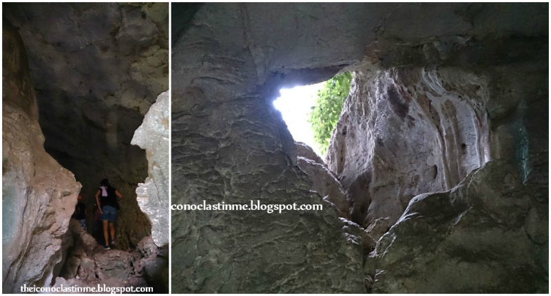
Where the rock formations end, the trail picks up and continues along some wooded area, leading towards the mouth of a cave.
Spelunking
The next activity is cave exploration. The tunnel that traverses the cave is short. There’s nothing special about the cave, and there’s even a part where one can smell urine. The okay part is where the temperature slightly goes down and the air suddenly turns cold. The cave’s terminal mouth picks up the trail, which goes back to the foot of the cliff, where one has to cross the same trail on the way back to the starting point.

For those who like adventures and can swim, cliff diving is a must-try. Locals can guide divers to areas where it’s safe to dive. Others can explore the upstream end of the river, wade in its shallow waters, and look for cascades in the foothills of the Sierra Madre. Also, there are other caves that can be explored. These are not part of the trail, though, and may be accessed with assistance from the locals.
Rock climbing on the cliffs’ wall/face would have been a fun activity, but it is reportedly prohibited as it might, apparently, destroy the cliffs' natural formation.
Tips
Minalungao does not have commercial establishments that offer lodging and cooked food. Those who plan to stay overnight should bring tents. There are a few makeshift stores along the riverbanks that sell basic commodities, including ice, softdrinks, liquor and beer. Sadly, though, the only food available that can substitute for a meal are canned goods. Vacationers are advised to bring their own food or buy some along the highway.
The recommended sequence of activities is as follows: trekking, then hill climb. Don't do the hill climb ahead of the other activities. You'll be very tired at the end of the climb. Hire local guides. They know the way around. Plus, you'll be helping the community earn a living.
DENR, in partnership with a private corporation, has already delineated a development program for the national park, as it were to tap its ecotourism development potential. Construction is currently underway and, with its rollout in the next couple of years, the program is expected to draw more tourists to the site and bring more jobs to the residents.
Hopefully,
the development scheme will not destroy the landspace and will not endanger the
integrity of the protected area. Also, the locals should, above all else,
benefit from the expected increase in tourist visits.
Summary of Expenses*
(May vary depending on the time/season of travel)
It's high time Minalungao, as a "national park," got the recognition and attention it deserves. More people need to know its national importance as a protected ecotourism area. With
proper maintenance, a sustainable development plan in place, and better promotion from the Department of Tourism and the local government of Nueva Ecija, Minalungao can evolve
to become a major tourist draw for the
province and the municipality of General Tinio. Hopefully, this gradual commercialization
will not pose hazards to the “raw” and "pure" qualities that add to the
allure of this natural wonder.

Minalungao National Park
Established in 1967 by virtue of Republic Act No. 5100, the park is “a protected area of the Philippines located in the municipality of General Tinio, Nueva Ecija in Central Luzon. The park covers an area of 2,018 hectares centered along the scenic Penaranda River bordered on both sides by up to 16-meter high limestone walls in the foothills of the Sierra Madre mountain range.” (Wikipedia) The statute mentions that the park is “situated in the municipalities of Gapan and General Tinio,” but the portion of the park that is of focal interest for tourists is under the jurisdiction of the municipality of General Tinio. The tourist hub of this protected area, governed by the Department of Environment and Natural Resources, is situated in Sitio Minalungao, Papaya, old name of General Tinio.
 |
| Minalungao National Park, circa1930, retrieved from the Magazine called PAPAYA - Papaya Picnic Michigan issued August 6, 1994, organized by Hubert Abes Bautista and Narciso Rivera. Photo courtesy of Justino Ramos Ilaya (cited in the Facebook page "Minalungao National Park," https://www.facebook.com/pages/Minalungao-National-Park/197717200264892) |
"Minalungao" was derived from the terms "mina" and "lungao," which collectively mean "mines of gold in caves."
How To Get There
Gapan City is the main gateway to the national park. Alternative routes can be taken from Penaranda and Cabanatuan City. In Cubao, Quezon City, buses going to Nueva Ecija abound at the terminals of ES Transport, Five Star, and Baliwag Transit. Take Cabanatuan-bound buses that ply the old route, which spans Marharlika Highway along Bulacan and Nueva Ecija. The travel costs 160 Php and takes 2.5 to 3 hours, depending on the time of day and the traffic. Drop off at Bucana, Gapan. Note: Buses with the “SCTEX” signboard travel along Pampanga and Tarlac and do not pass by Gapan.
From Bucana, Gapan, rent a tricycle going to Minalungao, round-trip, which costs 500 Php, on average. Alternatively, one can ride a tricycle from Gapan to Papaya (General Tinio) and then ride another one from there going to Minalungao. This costs more, though. The trip from Gapan going to the park takes 1.5 hours, depending on the sturdiness and road-appropriateness of the vehicle used. The tail end of the route is dirt and bumpy road. Luxury cars and sedans might not withstand the rugged and rocky portions of the road.
On return to Manila, one can wait on the highway at Bucana, Gapan for buses going to Cubao, Pasay, or Manila. Alternatively, one can take a jeep or bus ride to Cabanatuan (a good 30 minutes' travel), drop off at the Central Transport Terminal, and then ride a bus going to various points of Manila. SCTEX and non-SCTEX routes are available until early evening/night. SCTEX-plying buses have shorter travel time.
 |
| The "catch basin" |
How To Get There
Gapan City is the main gateway to the national park. Alternative routes can be taken from Penaranda and Cabanatuan City. In Cubao, Quezon City, buses going to Nueva Ecija abound at the terminals of ES Transport, Five Star, and Baliwag Transit. Take Cabanatuan-bound buses that ply the old route, which spans Marharlika Highway along Bulacan and Nueva Ecija. The travel costs 160 Php and takes 2.5 to 3 hours, depending on the time of day and the traffic. Drop off at Bucana, Gapan. Note: Buses with the “SCTEX” signboard travel along Pampanga and Tarlac and do not pass by Gapan.
From Bucana, Gapan, rent a tricycle going to Minalungao, round-trip, which costs 500 Php, on average. Alternatively, one can ride a tricycle from Gapan to Papaya (General Tinio) and then ride another one from there going to Minalungao. This costs more, though. The trip from Gapan going to the park takes 1.5 hours, depending on the sturdiness and road-appropriateness of the vehicle used. The tail end of the route is dirt and bumpy road. Luxury cars and sedans might not withstand the rugged and rocky portions of the road.
 |
| Concrete part of the route |
The travel offers tourists panoramic views of rice fields, gently rolling slopes and sometimes craggy terrain of the countryside. The route ends at the welcome marker, bearing the name of the park, erected on a mound. From the marker, a further drive or short walk downhill will lead tourists to the foot of the slope, a junction, a sort of open dirt “lobby” or “reception area” where some vehicles can park, tourists can ask for information and hire local residents as guides. On weekends, youngsters and teenagers do guiding chores to earn some bucks. There is no fixed rates for guides, but a reasonable rate is 100 Php to 150 Php per guide. It is customary that two guides accompany a group of vacationers. They stay with the group in activities that required their knowhow, such as trekking, spelunking, uphill climbing, rafting, and cliff diving.
The "junction" adjoins a small bridge, crudely made of steel, that can only carry pedestrian traffic. Facing the “catch basin” portion of the river, where some cottages made up of bamboo and nipa line its banks, one can see parts of the ravine, the central spot of the protected site, to the right, and the meandering portion of the river to the left. From the junction, one can take the bridge, where the trek along the cliff starts, or descend toward the flat bank of the “catch basin,” where the cottages are located.
 |
| Rows of cottages line the catch basin's perimeter |
‘Catch Basin’
Activities start here. Along its banks are cottages where tourists can eat, rest, hang out, and even cook food. Rental rates for the cottages depend on the season, the cottage owner, one’s bargaining skills, and perhaps the number of occupants. During off-peak seasons, prices may start at 200 to 250 for a cottage unit. During peak seasons, usually summer and Holy Week, prices may rise to 500 per unit. A higher rate (800 on average) applies for floating cottages, which can navigate the main river and anchor at certain spots.
 |
| Cottages line the catch basin's perimeter |
 |
| Floating cottage |
 |
| Floating cottages |
One can swim on the edges of the river, but may need to refrain from wandering towards the inner waters, as it gets deeper towards the center. Locals are quick to remind tourists that the deep part of the basin is infamous for pulling those who drift towards it and that it has taken many lives. Children can build sand castles on the banks. Others can roam around and go towards the shallow part of the river where it starts to meander downstream. They can wade across the mildly gushing waters over stones and pebbles towards the other side of the river, where there are other cottages.
The Ravine and the River
What I call the “ravine” is the valley formed by the flow of the Penaranda River. The calm waters of the narrow river straddle two towering limestone cliffs. The water in this area of the river, fed by headwaters coming from the Sierra Madre, is green and pristine and the unique rock formations at the bottom part of the karst cliffs appear whitewashed or like asbestos in color when struck by noontime sunlight. This ravine-river system is the centerpiece of the entire Minalungao experience. It constitutes the allure and grandeur of the national park.
The Trek
The other activity besides swimming that is a must-do for tourists, especially to the adventure seekers, is trekking. The entire trek is actually short but can be difficult as most of it entails some climbing and holding onto rocks and boulders. Think of rock climbing, but without the pegs and a rope to support you and minus the vertical, mostly 90-degree, climbs. The trail begins at the bridge, leading towards some boulders and a sort of “viewing deck,” which is just a cemented square pad where one can have a vantage point of the catch basin and the downstream river, the hill that bears the cross and the “grotto” and where a resort/hotel is being constructed, and major portions of the ravine and the green waters. Elderly people, young children, and those who don’t have enough stamina are encouraged not to go beyond this point.
 |
| Bamboo bridge connecting two points of the trail |
 |
| The river's upstream end, where shallow waters await visitors |
 |
| Left: wooded part of the trail; right: a view from the woods |
 |
| View from the wooded part of the trail |
Where the rock formations end, the trail picks up and continues along some wooded area, leading towards the mouth of a cave.
Spelunking
The next activity is cave exploration. The tunnel that traverses the cave is short. There’s nothing special about the cave, and there’s even a part where one can smell urine. The okay part is where the temperature slightly goes down and the air suddenly turns cold. The cave’s terminal mouth picks up the trail, which goes back to the foot of the cliff, where one has to cross the same trail on the way back to the starting point.
 | |
| Return route |
River Rafting
Rafting affords one the opportunity
to navigate and experience the river up-close. Rental rafts, balsa in the vernacular, are available
for this activity. Rates can go as low as 80 Php for seat-less units and 100
Php for those with seats. Prices increase during peak season. One’s guide will or
can serve as boatman. The route starts from the catch basin and traverses
a certain portion of the basin, then enters the main river towards the upstream
end, where one can enjoy swimming and wading in the shallow waters coming from
the foothills of Sierra Madre. Going back, the raft takes the same route, this time
downstream, towards the starting point.
 |
| Seat-less raft |
 |
| Raft with seat |
1,000 Steps, Minalungao Cross
To complete one’s stay at the park,
one can try climbing the 1,000 paved steps on the slopes of a hill towards the
summit. This proves to be an endurance challenge and a cardiovascular exercise.
One has to bring some water as no supply is available along the zigzag trail.
Within the first quarter of the trail, a nipa hut awaits weary climbers.
At the peak, a cross stands at the center of a polygonal rotunda-like structure
bordered by columns. The spot offers one a bird’s eye view of the entire forest
park and the Sierra Madre mountain range. A pseudo viewing deck is situated some
few feet below this point. According to a local youngster serving as a tourist guide,
a grotto is in the works in this area.
A raft is needed to transport tourists to the foot of the hill where the 1,000 steps begin.

A raft is needed to transport tourists to the foot of the hill where the 1,000 steps begin.
 |
| Right: View from the hill |
 |
| The hill's zenith |
Other Activities
For those who like adventures and can swim, cliff diving is a must-try. Locals can guide divers to areas where it’s safe to dive. Others can explore the upstream end of the river, wade in its shallow waters, and look for cascades in the foothills of the Sierra Madre. Also, there are other caves that can be explored. These are not part of the trail, though, and may be accessed with assistance from the locals.
Rock climbing on the cliffs’ wall/face would have been a fun activity, but it is reportedly prohibited as it might, apparently, destroy the cliffs' natural formation.
Tips
Minalungao does not have commercial establishments that offer lodging and cooked food. Those who plan to stay overnight should bring tents. There are a few makeshift stores along the riverbanks that sell basic commodities, including ice, softdrinks, liquor and beer. Sadly, though, the only food available that can substitute for a meal are canned goods. Vacationers are advised to bring their own food or buy some along the highway.
The site also doesn’t have modern drainage and
sewerage facilities. There is a toilet for calls of nature, but there are no
showers and faucets to rinse and refresh oneself. There is a makeshift “comfort
room,” though, where one can change clothes and do some washing, courtesy of water
taken from the river itself.
Sustainable Development
DENR, in partnership with a private corporation, has already delineated a development program for the national park, as it were to tap its ecotourism development potential. Construction is currently underway and, with its rollout in the next couple of years, the program is expected to draw more tourists to the site and bring more jobs to the residents.
 |
| Source: Facebook page "Minalungao National Park," https://www.facebook.com/pages/Minalungao-National-Park/197717200264892 |
Summary of Expenses*
(May vary depending on the time/season of travel)
Here is a sample scenario:
Time/season of travel: March 2014
Number of persons: 3
Bus fare (Cubao-to-Gapan) –
480 (160 per head)
Tricycle (Gapan-Minalungao,
round-trip) – 500
Toll/Entrance fee – 75 (25 per
head)
Food (lunch and merienda) –
300
Cottage – 250
Raft – 100
Tour guides – 300 (for two
guides)
Contingent expenses (e.g.,
ice, snacks, refreshments) – 100
Bus fare (Gapan-to-Cubao) –
480 (160 per head)
Total costs (Group) – 2,585
Costs
per person – 861
*NOTE: Rates are as of the date of this trip. They can vary, depending on your haggling/negotiating skills. Some drivers will only carry two adults, depending on their weight, per ride, as portions of the Papaya-Minalungao-Papaya travel are rough and bumpy.
VERDICT
The Minalungao National Park
is a natural wonder. I was surprised, and at the same time
amazed, that a place this beautiful actually exists within the boundaries of Nueva
Ecija. I thought the photos I had seen on the Net were exaggerated. But they
were not. Minalungao is as beautiful, if not even better, in real life. Its ”wow” factor resides in the pristine green river and
the unique rock formations that form part of the limestone cliffs. And part of its charm are its virginal and unexploited qualities. The only other
river system that I can think of that can beat the breathtaking beauty of this
place is Palawan’s Underground River.
Minalungao offers a budget travel experience (see summary of expenses above) not too far from Metro Manila. It is one of the few remaining natural environments in Central Luzon and boasts one of the best river valleys in the country. For those who have experienced the wonders of the country's endless saltwater beaches, Minalungao's freshwater grandeur and karst landform offer a refreshing change of scenery. The splendor of the park's clean and green freshwater (in combo with the unique rock formation that flank it) can rival the popular saltwaters of Puerto Galera and Alona Beach and even outshine Loboc River, the last two both located in Bohol.

Many Novo Ecijanos do not know this site exists, so it's unsurprising that only a few Filipinos know about it. For some who have heard or known of it, they don't even know how beautiful it is. When asked by friends about tourist spots in Nueve Ecija, I often feel embarrassed to say there is nothing really special about it. Well, now I can be proud of my home province and will not hesitate in promoting it to my friends and others who want to discover new places.
Minalungao offers a budget travel experience (see summary of expenses above) not too far from Metro Manila. It is one of the few remaining natural environments in Central Luzon and boasts one of the best river valleys in the country. For those who have experienced the wonders of the country's endless saltwater beaches, Minalungao's freshwater grandeur and karst landform offer a refreshing change of scenery. The splendor of the park's clean and green freshwater (in combo with the unique rock formation that flank it) can rival the popular saltwaters of Puerto Galera and Alona Beach and even outshine Loboc River, the last two both located in Bohol.
Many Novo Ecijanos do not know this site exists, so it's unsurprising that only a few Filipinos know about it. For some who have heard or known of it, they don't even know how beautiful it is. When asked by friends about tourist spots in Nueve Ecija, I often feel embarrassed to say there is nothing really special about it. Well, now I can be proud of my home province and will not hesitate in promoting it to my friends and others who want to discover new places.
Wow, like your blog, the details you provided are all very helpful.
ReplyDeleteThanks so much for the appreciation!
DeletePwede ba mag stay for 1 week is there any comfortable place to sleep like hotel any information po please 😊
Deletemy contact po b kau trike gapan to park? me nainquire po ako 800..nkita ko sa blog nyo 500.pssible po ba na mg river trekking pagdting den hike hill den river rafting ba pblik?
ReplyDeleteHi, Maria. Rates are as of the date I made the trip. They can depend on your haggling/negotiating skills. I'm a local, so I knew my way around. Note, too, that some trike drivers will only carry two persons per ride, as the travel from Papaya to Minalungao is rough and bumpy. The best sequence of activities is as follows: trekking, hill climb, rafting. Don't do the hill climb ahead of the other activities. You'll be very tired at the end of the climb.
DeleteYou can contract/hire trike drivers at Bucana, Gapan. Haggle/negotiate wisely. :)
Deletehi marla, meron din ako nakausap don, 800.00 din singil nya sa trike, round trip na from gapan - park - gapan.
ReplyDeletePwede po ba kaming magdala ng sasakyan instead of trike?
ReplyDeleteDo you recommend a motorcycle/scooter going to Minalungao? Thanks. Awesome blog.
ReplyDeleteI don't drive motorbikes, so I can't definitively answer you, but I've seen bikes and scooters, yes. Depends on you, your bike, and whether you have somebody riding with you.
DeleteHi! Nice blog and very informative.. ;-)
ReplyDeleteI have a question lng po, how many hours usually ung trek plus all other activities?..am thinking if it may take my half day off spent in the road going there.. thanks..
Hi! Nice blog and very informative.. ;-)
ReplyDeleteI have a question lng po, how many hours usually ung trek plus all other activities?..am thinking if it may take my half day off spent in the road going there.. thanks..
Thank you for providing valuable information about this breathtaking tourist spot in the province of Nueva Ecija. 😊👏 I would like to visit this beautiful place soon. When in Nueva Ecija, the best hotel to stay is the Harvest Hotel in Cabanatuan City. https://www.facebook.com/theharvesthotel
ReplyDeleteHope u give me information to this query po.. We are from san antonio nueva ecija po.. Salamat..:)
ReplyDeleteHi! Were planning to visit minalungao park on may.. Were going to celebrate my mother's bday and mother's day as well..Were a big group about 20pax.. Is it ok to bring a van..? We have two vans.. safe park our van in the park..? Or they have private parking area for the private cars..?
ReplyDeleteHi. Question po how much is the caving fee? Thank you.
ReplyDeleteas for my experience "no fee" for caving.
Delete